umpcportal home

Tag Archive | "gps"

Tracking saves the day. $3000 of equipment, and thief, found!


I wrote last Thursday about how my old technology would be useful while I was away on a weekender but something happened during my weekend in Holland that puts another angle on the tactic. Perhaps an expensive smartphone is worth taking with you because we had over $3000 of smartphones and laptops stolen from a holiday home at the weekend and because one of the stolen items had GPS tracking enabled we were able, with the help of local police, to find the equipment and thief in under 2 hours.

WP_20150509_11_28_35_Rich
‘Headless’ friends in Holland wish to remain anonymous.
Read the full story

Lenovo Yoga Tablet 2 8 thoughts and videos. (P.S. I’ve ordered one)


I can’t get the Lenovo Yoga Tablet 2 8 off my mind.

Lenovo Yoga Tablet 2 8 (4)

What has the Surface Pro 3, the Flex 10 and the Samsung Q1u got in common? A stand! The Lenovo Yoga tablet 2 8 (and 10-inch) has a stand too and at under 1 pound / 426 grams it’s the lightest self-standing PC in the world. That makes it interesting for me, especially as it’s got a 1920×1200 screen, a big battery, an LTE option and a starting price of just $299 (dual-band WiFi version.) According to a retailer in Germany that has it up for pre-order there’s a digital compass and GPS. This is too good. I hope not though because I’ve just ordered it. I’m expecting an early November delivery.

Lenovo Yoga Tablet 2 8 specs and more information.

The other interesting aspect here is the battery. This isn’t the lightest 8-inch Windows PC because it’s got a huge 24Wh battery inside. In comparison to the Lenovo Miix 2 8, which is one of the lightest, it’s got 35% more capacity. [The capacity is quoted at 6500 mAh. We can assume that it’s based on a 3.7V battery. Anything else would be too much for this weight.]

Take a look at some of the images and imagine the use cases here. Bluetooth keyboard, kitchen, seat-back, car, armchair…

Lenovo Yoga Tablet 2 8 (5)Lenovo Yoga Tablet 2 8 (6)

Lenovo Yoga Tablet 2 8 (7)Lenovo Yoga Tablet 2 8 (8)

Lenovo Yoga Tablet 2 8 (1)Lenovo Yoga Tablet 2 8 (2)

Lenovo Yoga Tablet 2 8 (3)

Wolfson® Master HiFi™ audio processing and Dolby® surround sound

Don’t forget that Lenovo are touting good speakers too so the Yoga Tablet 2 8 could end up being your hotel-room best friend.

The camera could be the best camera yet on a Windows tablet…8MP rear camera with f2.2 wide-aperture lens, advanced glare-reducing glass and a BSI 2 sensor.

Lenovo Yoga Tablet 2 8 (Windows) issues.

Here are the trade-offs you’ll have to consider. 1) It’s not the lightest. The Dell Venue 8 Pro remains the best ‘reader’ Windows tablet on the market. 2) The stand/battery might improve the portrait reading experience but it might cause problems when thumb-typing. 3) There’s no HDMI port. You’ll get Miracast for video-mirroring but it’s not good enough for an interactive experience in my opinion. DisplayLink over USB 2.0 works for basic office use though. 4) The SoC isn’t going to be any more powerful than those of the first-generation Baytrail tablets although there’s a possibility that the eMMC could be faster as it is on the Toshiba Encore 2 8 tablet. 5) Still no USB 3.0 and the charge+data issue remains. There may be hacks for the latter issue.

If you’re not feeling it for the Yoga tablet 2 yet, take a look at this video from Mobilegeeks. I’ll add more to this playlist.

4 weeks to wait for my hands-on. Can you wait that long or are you pre-ordering?

Lenovo Yoga Tablet 2 8 specs and information in our database here.

Ultrabooks feature in the Intel ‘Compute Continuum’ at MWC


I’m at the Mobile World Congress  in Spain this week and although I’ve been covering a lot of phone and tablet news (over at Carrypad.com) I’ve also been keeping an eye open for Ultrabook news. I didn’t have to look far because when Intel talks about one silicon product, it’s now inextricably linked with the others via the ‘Compute Continuum’ which isn’t just a keynote dream any more, it’s a real project to mesh devices from various parts of Intel’s product range.

intel cc


Read the full story

Next-Gen Mifi Firmware Includes GPS and Apps. Demo Video.


As promised at CES, Novatel are moving forward with their plans for the Mifi 3G personal mobile internet hotspot (that has been a life-saver for me at MWC) to include applications and software features. We spoke to the team at the Mifi booth at MWC a few days ago and got a nice demo of a GPS-enabled application. GPS is enabled in the next firmware but I’m getting the impression that it’s going to be a new model of the Mifi with slightly newer features which ‘might’ include, USB charging without becoming a device, better battery life and of course, the GPS. I’m hoping that the firmware comes to existing Mifi’s (or at least the ones with the application processor in them) to enable the GPS that’s already included in the unit.

In the video below, Gareth Davis talks about some of the things possible and demonstrates a nice GPS-enabled application served through the Mifi webserver itself.

We have also heard that the EyeFi (Wifi-enabled SD card) application is progressing and we’ll be sure to keep a close eye on it.  Clearly a web-based navigation service would be possible and there’s a ton of things that can be done with social networking. Can anyone think of other interesting apps that could be created on this platform?(Apart from the obvious ‘free wifi’ password-inspection app that would be sure to pick up some interesting information if you left it for a few hours in a press conference!)

Twitter and GPS will have a major impact. Advertising first.re


The problem with launching a location-enabled service is that there are hundreds of other services already out there. The early adopter user base is spread all over these services and it makes it hard for any to gain traction and critical mass. The other problem is that each application has a fixed use as defined and programmed by the developer which means it may not hit the target requirement.

I’ve always said that Twitter needs out-of-band GPS  information in order to make tweets more relevant to the user and to be able to filter out countries or events when needed and the announcement from Twitter last week that they are working on it literally kept me awake the other night as I thought about the scenarios that would form.

There are two great things about Twitter that make this announcement very interesting. First is that Twitter has millions of users. It’s well established and well past the critical mass needed to keep it going. Secondly, Twitter won’t be making the apps themselves. Just as before, apps will be developed by third parties that dream up cool ideas meaning you can switch between clients and features without losing your data or history. This makes is quite unique and as far as I’m concerned, lines Twitter up to be the #1 location based service within a very very short time.

Clearly there are security and privacy issues to be dealt with. One hopes that Twitter puts strong guidelines in place and that application developers will consider them but ignoring that for a minute, just think about what’s going to happen.

Location means mobility and GPS. Of course you’ll be able to take advantage of location data on your desktop or laptop but the smartphone and mobile internet operating systems are where the action is going to really happen and are really going to be fun. Smartphones with GPS will be able to add location information and show local information either as a separate search or highlighted in the normal stream as you move through different areas. PC’s will fall behind here.

A few ideas…

  • Viewing historical location information
  • Viewing live local information
  • Friend Radar
  • Local Events
  • Local advertising

One area where geo-enabled tweets will take off immediately is local advertising. Imagine you are tuned into a local stream of everything going on, which I imagine a lot of people are going to do. It only takes one geo-enabled tweet from an advertiser to appear on your stream. ‘Big Mac available half price for the next 30 minutes’ or ‘Happy Hour just started at Coopers’ or ‘Tracy is bored. Wanna meet round the corner?’  is a message you’re going to see a lot. Companies with large numbers of outlets are going to be banging out location-based twitters in huge numbers. Many times more than they did previously! Accounts with _us or _uk at the end will be common too as the advertisers try and hide the big amount of advertising going out!

Unfortunately, the rewards in this area are going to be big and application developers and advertisers will jump on it very quickly. I really hope it doesnt damage the Twitter / Geo ecosystem before it becomes really useful. Having a high-rate account option on Twitter to transport this information is a must-have. This could be an important revenue stream for Twitter while providing an easy way to control the information.

Friend Radar is one to watch although having a blanket on/off location service is going to be difficult. Google Latitude sorted this problem out early with per-friend sharing. Again, it depends on how the applications develop. Sub-accounts or groups (as per Friendfeed) could be a way to deal with it. Joining with Google is another option!

Events and information will take off quickly and it would be great to see busses and trains tweeting their location in real time. Weather agencies need to get up to speed on this too. It’s not only very interesting for many people to know the weather, it’s a very very simple way to save lives. Road traffic information is a good application too and I can’t wait for the first 3G and twitter-enabled navigation application. Nokia are in a good position to be able to do this on Maemo very quickly.

The possibilities are endless and with such a head start and open ecosystem it’s possible that twitter becomes the de-facto channel for sharing ANY geo data. In my opinion, Twitter have just positioned themselves as an important layer for the Internet. Early players will stand to gain a lot.

Twitter: Location, Location, Location

Coach bus driver using Samsung Q1 Ultra for navigation solution


photo I was recently on a trip which took me on one of those big coach buses. A friend inquired to me as to whether the bus driver was using GPS or if he just knew where he was going. I assumed that he’d be using some sort of GPS, but I wasn’t expecting that he’d be using a popular ultra mobile PC at the center of his navigation solution. It was interesting to see a Samsung Q1 Ultra [Portal page] in the wild, and apparently being used quite effectively. I was able to snap two quick images with my iPhone; sorry about the quality, the lighting was not in a favorable position.

The bus driver was an older man who looked to me nearing or into his 60’s. I wasn’t sure if the Q1U based navigation system was devised by him or supplied by the bus company. Again to my surprise, the system was set up by the bus driver himself. I suppose the old “book by its cover… inch adage is suitable here. I exchanged just a few quick words with the driver about the setup. I wasn’t able to capture all of it, but it sounded like he was using some pretty powerful industry navigation software to map routes effectively. I believe he was using a Bluetooth GPS unit to obtain nav data, and I saw an AT&T branded unit which I’m assuming provided 3G data, but it looked a bit old and could have been EDGE only.

photo (1) Nearly every part of the setup was mounted right on the windshield, it was pretty cool. The Q1U looked to be using a suction mount designed specifically for it. There was a DIY looking sunshade to block direct sunlight and make sure that the screen stayed readable. The sunshade looks to consist of two separate pieces and be resourcefully held together with velcro, which I would imagine makes it easy to break the setup down and pack it away. On top of the sunshade was a USB hub which provided four USB slots, in one of them a USB memory stick was plugged in. The GPS unit and AT&T data unit were both mounted to the windshield as well.

Pretty cool to see this nice navigation setup. I imagine that the driver is able to do much more than similar drivers who are using simple consumer GPS units.

Is anyone else out there using a ultra mobile PC for their in-car navigation needs?

How Location-Based Services could help ARM-based MIDs


Location-based services are an exciting and interesting area of mobile computing. Carriers, advertisers, developers and consumers all seem to understand the potential and as social networking grows in popularity, these services could be big sales drivers.  If these services become deciding factors for consumers in the mobile device space, mobile platforms that don’t support them will clearly suffer.  Leading mobile platforms like the iPhone, Blackberry, Android, Maemo and Symbian that are all based on ARM cores have a big head start over x86-based operating systems and it’s looking likely that it will stay that way.

Consider these points.

1 –  It’s likely that nearly every high-end mobile phone will have GPS built-in within the next 24 months. ABI predicts 90% of smartphones will have GPS by 2014. Most early adopters in the Internet space are likely to have a phone with a GPS in the next 12 months, if not already. Nokia are planning to have nearly all N and E-Series phones with GPS within the next 2 years.

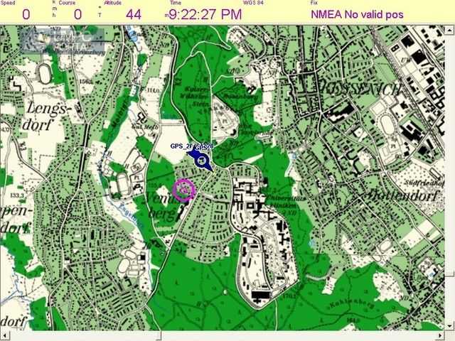
2 – Apart from the small numbers of deployed GPS modules on PCs, UMPCs and MIDs, developing applications on a PC that integrate smoothly with GPS remains difficult. Consumers can not be expected to enter COM port and baud-rate details into their software configurations.

3 – Broker services. Why use a local GPS modules on a PC, even a mobile one, when a broker service (like FireEagle ) can not only provide your location to all your cloud-based services but also back to your PC-based app? Because of the PC-based development problem identified above,  social networking clients on PC’s will probably take this ‘least-effort’ route in order to tag microblogs and media with location.

map1

There are of course reasons why you might want GPS on your PC.

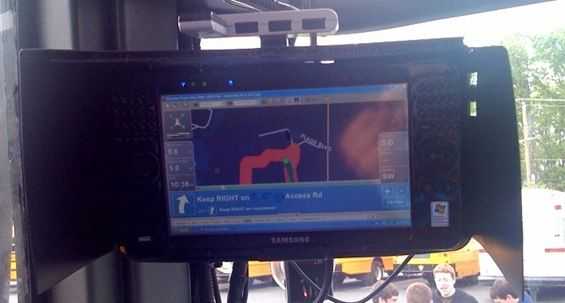
1 – Your PC is used for real-time GPS data. (Turn-by-turn navigation, tracking and data collection.) This applies to ultra mobile PC users and CarPC users. Broker services would have too much latency for real-time services. Specific applications and target markets will continue to exist.

2 – Your PC is not connected to the Internet and therefore can’t use a broker service.

3 – Why not? GPS modules are cheap.

The clear likelyhood is that the software developers will continue to focus their LBS efforts on smartphone platforms due to the ease of access to GPS information and the number of GPS-enabled devices out there. There are one or two options for X86-based platforms though. Geoclue and Moblin teams are working on getting this LBS issue resolved for the Intel-based MIDs but they need to work quickly. An Android port could also seed interest in the x86 platform for these applications.

Does this mean that the smartphone wins? Not yet. There are problems that need to be addressed because GPS-enabled applications are dynamic, require a lot of cpu power and a lot of screen space. Mobile phones are low-powered (in terms of CPU and online/gps battery life) and have small screens which make them less than ideal despite their GPS-friendly operating systems. This is why MIDs will come along to satisfy the need for larger screens, larger batteries, keyboards and higher processing power. Significantly, for LBS developers, they will come in both x86 and ARM-based flavours so there will be no need for location-based software developers to change to a new architecture just to get round physical limitations of smartphones. The ARM-based MIDs will be there to fill that gap and provide the perfect platform, in terms of both hardware and software, for rich and dynamic LBS services.

If location-based services become successful it will give smartphone-based MIDs a huge head-start over X86-based MIDs. My personal feeling is that GPS-enabled social networking is going to be very important and is likely to drive sales of devices that support. X86-based MIDs are at a serious disadvantage.

Lists of location-aware software and services:

Are you involved with location aware software development? If so, are you interested in writing software for Moblin or ‘desktop’ operating systems or are you going to focus your efforts on mobile platforms? Which is your favourite mobile platform for location-aware software development?

Note: I haven’t covered triangulation services here as I believe that they only have a secondary role based on their closed architecture, inaccurate results and the proliferation of handset-based GPS modules and open broker services.

How will your computing habits change when we reach all day battery life?


batteriesThis thought popped into my head today for no reason what-so-ever and I wanted to see if I could get a discussion started.

Imagine this: One year ago, there was a huge battery breakthrough. All of your mobile tech gadgets have a battery that is good for an entire day of computing. I’m not talking about what a big company calls “all day computing inch (maybe 8 hours?), I mean 24 hours of continuous use on a single charge no matter what task you are doing.

Now answer these two questions:

  1. How would your current computing habits be different (other than ‘work longer’)?
  2. Two years down the road, what would gadgets evolve into, knowing that they were designed with all day battery life in mind?

When you are done, tag some people who you’d like to hear thoughts from.

Allow me to start:

How would your current computing habits be different?

First of all I think I would remove all of the wireless radio toggle software from my devices. Why turn them off if we have the power? Second, I might carry a more powerful device as my pocket computer. I would probably use the UX180 in place of my current iPhone, knowing that I could get more done on the 180. There probably wouldn’t be much need to turn my devices off so I would have an always online status. Services like Google Latitude would be active on my devices so friends could see me and I could see them.  I used to carry my UX around in my pockets, but I also needed to bring the AC adapter with me.

Two years down the road, what would gadgets evolve into knowing that they were designed with all day battery life in mind?

I think that smaller devices that would function as notifies would become popular. Envision a normal looking wrist watch, that has 3G connectivity and GPS, aggregating all of your notifications (email, IM, social networks, etcetera) and tells you what is going on right then, without having to pull something out of your pocket. I imagine a vibration from the watch letting me know that a friend is nearby (located with something like Google Latitude), and clicking a button on the side of the phone at that time would connect via Bluetooth to my phone and call my nearby friend. The watch would display other short info like micro-blog updates or SMS from my phone right on its own screen. I think that HD content would be much more prevalant, given that even handheld cameras would be powerful enough to do all day HD recording. This might have an affect on demand for faster bandwidth because people would be flocking to YouTube to be uploading or watching lots of HD videos, and they would want to do it with the same speed that they are used to watching SD videos.

Tag, you’re it:

Jenn from Pocketables.net

James and/or Kevin from JkOnTheRun

Also, link back to the people that linked to you, so they know that you responded.

Follow Chippy on  TwitterFollow Chippy on  YouTube

The most popular UMPCs on UMPCPortal