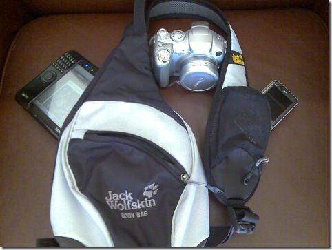
In the previous post I talked about my requirements and the three pieces of hardware that I would use to help me. To recap, here they are again.
Requirements:
- Location. Where am I now? Exactly?
- Turn-by-turn, step by step. Where do I need to go. How long will it take?
- Public transport. Where is it? When does it depart and arrive?
- Phototagging. Ensuring that my images are tagged with their location
- Live location tracking and networking. Allowing other people to view my location and to enable notifications when friends are near.
- What’s near me? How do I find the nearest hotel? Wifi? etc.
- Location tracking. How to I archive my locations and route?
- Map mashup. How do I create a map that shows my tracks along with all the ‘e-things’ I did along it. Photos, blogs, podcasts, twitter updates etc.
Devices:
- A GPS-enabled smartphone
- A mobile internet device
- A GPS Tracker
Now we have to tie those devices to software services in order to achieve the requirements. Lets take each requirements one-by-one.
Location. Where am I now? Exactly?
This is a simple one for me as my smartphone, a Nokia N82 is GPS-enabled and comes with an excellent mapping system built-in. Nokia Maps 2 offers detailed maps along with a local or internet-based search facility that links with the built-in GPS. Similar solutions are available on other phones and more and more phones are appearing with maps and GPS built in. Google also have a mobile application for many phones now which links into GPS, local search, 3D building representations and street-level photography.
The ‘desktop’ is way behind in this area and it will be a challenge for MID manufacturers to get service and software providers to move this geo=enabled functionality onto Windows and Linux. It’s starting to happen though. Intel have some good partners in their ecosystem (Gypsii is one very interesting one) and with the W3C geolocation API and services like Mozilla’s Geode and Yahoo’s FireEagle (check out 60 geo-enabled web services on their application gallery), it’s becoming easier to provide these services through the browser.
Turn-by-turn, step by step?
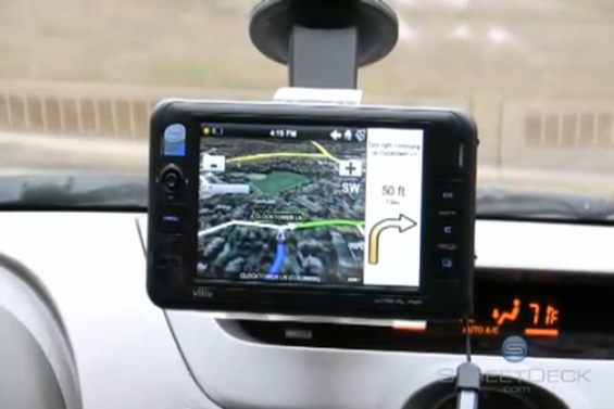
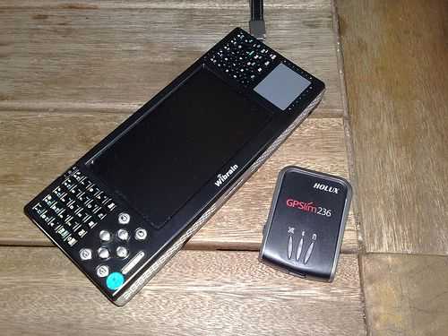
 Finding a route from A to B is freely available to everyone with a PC connected to the internet. Most of the main search engine portals offer the service and getting an efficient route printed-out is common practice but what if I need directions as I travel. Printouts are dangerous and if you’re on your own, the only solution is a dedicated unit with voice instructions. If you want to find your way around by foot, there are even fewer solutions. My mobile phone has these features built-in although they’re not free and having used them before, not easy to use in the car. A months license is €8.99 with traffic info on top for an additional fee and the solution works well but the screen size makes it extremely difficult. Instead of using the mobile phone for in-car turn-by-turn navigation, i’ll be using the Clarion MiND device. It’s a handheld PC designed specifically for the car and should be very interesting to use. The only problem i’m worried about is that it’s coming from the U.S. I hope it has EU maps on it!! If it doesn’t, i’ll use the Wibrain i1 with the PC Navigator software that i’ve used in the past.
Public transport.
Google are moving forward quickly with integrating public transport details into their mapping pplications. Unfortunately, only small areas are covered and not all transport methods are included. In Germany, i’m a big fan of what Deutsche Bahn have done with integrating bus and train timetables in a very reliable and efficient way. In my local area, I can even check on local bus delays as they’ve fitted GPS tracking and feedback into the busses. Impressive! My tour itinerary has changed a little since my first plan and wil probably be pre-booked so getting live public transport info won’t be such a big deal but i’m sure that there will still be a requirement for the info. Fast, full-screen google searches and access to interactive web sites is just the ticket for the ticket and this is where MIDs shine with their full web experience.
Phototagging / Geo Tagging.
Presenting my photo’s on a map at the end of the tour and to put them in some sort of order, tagging them with location co-ordinates is a must. In order to do this from my main digital camera I need to use a 3rd-party tagging service as this isn’t something built into the camera itself. I suspect that i’ll use the flickr map to position my photo’s, a third party tagging solution. See below for an interesting online alternative to photo tagging. Alternatively, i’ll just use the Nokia N82 as my camera. GPS tagging is built-in so for snapshots, it will be the easiest method.
Live location tracking and networking.
A fun part of the tour for the reader will be to watch my current location and to read the latest microblogs that go with it. If i’m able to add audio, photo and text in a timely manner it will tie it together as a great near-live journal. I’ve been testing ipoki.com for that last few weeks and am pleased with the results here. Ipoki provide a client for the PC and smartphone which allows you to update their server in real-time. They then update a live map which you can export and embedd in a website. The map updates as my location updates. This is fantastic stuff but I want more! It hasn’t been easy to find a GPS service and set it up and there are a few things missing from ipoki but for the time being, i’m happy with the results and will probably use this on the tour. You can track me on my page here.
Oh, I almost forgot. ipoki allows people to be friends onthe system and will alert you when they are near! Feel free to join up and ‘friend’ me. When I’m in your area you’ll get an alert and can take suitable evasive action ;-)
What’s near me?
Obviously this requires a huge points-of-interest database. Most dedicated navigation units have POI databases included and you can find hotels, garages and cash machines quite easily but when it gets down to details like ‘food at 10pm’ or ‘next postbox collection’ you need more than just a static database. Google’s map search feature is one of the best ‘what’s near me’ services i’ve found yet but the big problem is that their browser-based service has no idea where you are. It’s not even integrated with Geode (the Mozilla services that enables the browser to retrieve you location) so there’s some work to do here. You can use the Google Earth application but that’s too fat for occasional lookups. The same goes for the Microsoft Streets and Trips application. The best Google geo-enabled lookup services are only on phones at the moment and I guess that makes sense. PC’s were’nt ever mobile devices before now so why would people have developed quick, easy-to-use, internet connected mobile software for them? As we know though, firefox is getting more and more mobile by the day. Devices like the Aigo MID prove that and as these devices get more popular, browsers will need to be geo-enabled to keep up. Alternatively, someone like ipoki could just add the Google maps search feature into their desktop applet. If you have any tips in this area, let me know but for the time being, i’ll be using the Google Maps application on my phone for location-related search.
Location tracking and logging.
Take it from me, someone that tracked their 500km solar-powered computing tour, that tracking and logging your location is a CPU and battery-intensive application that neither a phone or a PC can do very well. In the past, i’ve used a cheap, dedicated unit from Garmin which can handle a days work on a two AA batteries but downloading the track and integrating it with other data can be a pain. Applications like Nokia’s Sports Tracker have done a good job in making it easy to add photos and upload to a server but there’s still a battery life problem. Using the Intel Atom-powered Wibrain UMPC, i’m able to do about 8hrs GPS logging but again, getting that data out and integrated into other sources is a pain.
One of the best services i’ve found so far though is the ipoki lifestream application. I mentioned ipoki above but one of the features I didnt mention was the tracking feature. As you submit your location to ipoki, it stores it in a log. Then, if you enable it, it will add your comments to the log and even fetch flickr photos and match the timestamps to the log and add links on the timeline. This means you can submit images to flickr from any source, through any method and they don’t need to be geo-tagged. Remember also that you can submit your location to ipoki through thebrowser (not geode-capable yet though) a dedicated Windows app (which includes messaging client that links through to twitter and sends messages from people or friends in your area), a Symbian app (no messaging on this one) and a Windows mobile app (messaging included) so given the battery-life problem, this is a great way to keep a log. There’s much more that can be done to ipoki but it’s a great start and I expect to see many more services like this pop up. Indeed, ther may already be services existing so let me know if you’ve found anything.
I’ll be taking the Garmin tracker as a backup because there will definately be times when I won’t be internet connected.
Map Mashup.
Blogs present informatiojn on a reverse cronological timeline and map mashups can present exactly the same media on a map overlay. Here’s a simple example from some testing I did in 2007.

Click to see the map.
If you click through you can see a moveable, zoomable map with a track and my points of interest. Each POI is clickable and pops up either text or an image.
The problem is that getting that data together is quite difficult.Geo-tagged images help but to get the rest of the media together can be quite a task. Ideally I would be able to geo-tag all my media and present it so that the user can switch between time and map views but I haven’t seen anypublication platform that enables that yet. The closest i’ve got so far is one of the features from ipoki. Here’s the third reason that i’ve chosen it for long-term testing.
I mentioned above that ipoki can create a log on it’s servers and pull in flickr and comment data well, the icing on the cake is that ipoki then allows you to export the data as a KML file which can easily be imported into most mapping software. Using this data with ‘My Maps’ on Google Maps makes it easy and fun to create media rich maps. Using Googles My Maps feature, I could easily create a media-rich tour using the ipoki data and some link in all my posts and embedd it in a webpage. This is exactly what i’m planning to do on the tour.
So there’s my take on Geo-enabled services. Its a new but fast-growing area for many in the web world and there’s a lot of money behind the development too. Google and others understand that location-based search enables location-based advertising which clearly would increase the value of advertising for everyone. Expect that list of 60 services to grow quickly in the next few years.